
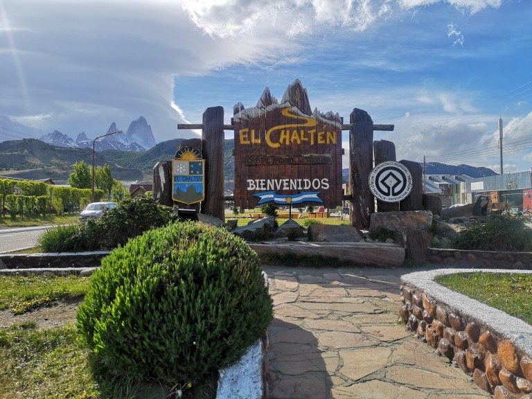
El Chalten is somewhat the underrated Mekka for hikers. It is located about three hours drive from El Calafate.
It is not as touristic as the Chilean version (Torres del Paine) but very much worth a visit!
—
El Chalten è un po’ il Mekka sottovalutato per gli escursionisti. Si trova a circa tre ore di guida da El Calafate.
Non è turistico come la versione cilena (Torres del Paine) ma merita davvero una visita!
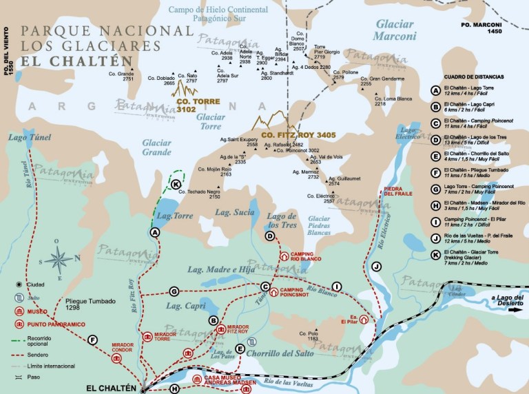
There are many trails that can be done on one day, or multiple trails combined can keep you away from home for days. (Make sure to bring a tent!)
—
Ci sono molti sentieri che possono essere fatti in un giorno, o più percorsi combinati possono tenerti lontano da casa per giorni. (Assicurati di portare una tenda!)
The most famous mountain in El Chalten is of course mount Fitzroy, 3.4 km above sealevel and the highest peak in the area. It was named after Robert Fitzroy, the captain of the Beagle, in honour of his work done in mapping the Argentine coast.
Of course it requires a professional mountaineer to climb the mountain. The closest “normal” hikers can go to is Lago de los Tres (D in above map)
—
La montagna più famosa di El Chalten è naturalmente il monte Fitzroy, 3,4 km sopra il livello del mare, la vetta più alta della zona. Prende il nome da Robert Fitzroy, il capitano del Beagle, in onore del suo lavoro svolto nella mappatura della costa argentina.
Ovviamente è necessario un alpinista professionista per scalare la montagna. Gli escursionisti “normali” possono andare a Lago de los Tres (D nella mappa sopra)
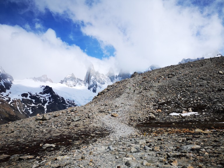
When we were climbing up, the weather looked great.
—
Quando stavamo salendo, il tempo sembrava fantastico.
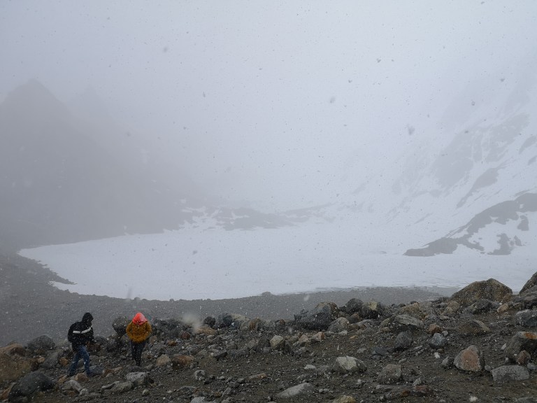
Unfortunately when we got to the lake (5 minutes after the previous picture), a snowstorm had just started and not much was visible anymore. That also answers the title of this post: wrap it in a snowstorm. 😎
—
Sfortunatamente quando siamo finalmente arrivati al lago (5 minuti dopo l’immagine precedente), era appena iniziata una tempesta di neve che aveva coperto tutto. Ed eccovi svelata la risposta al titolo di questo post: avvolgerlo in una tempesta di neve.😎
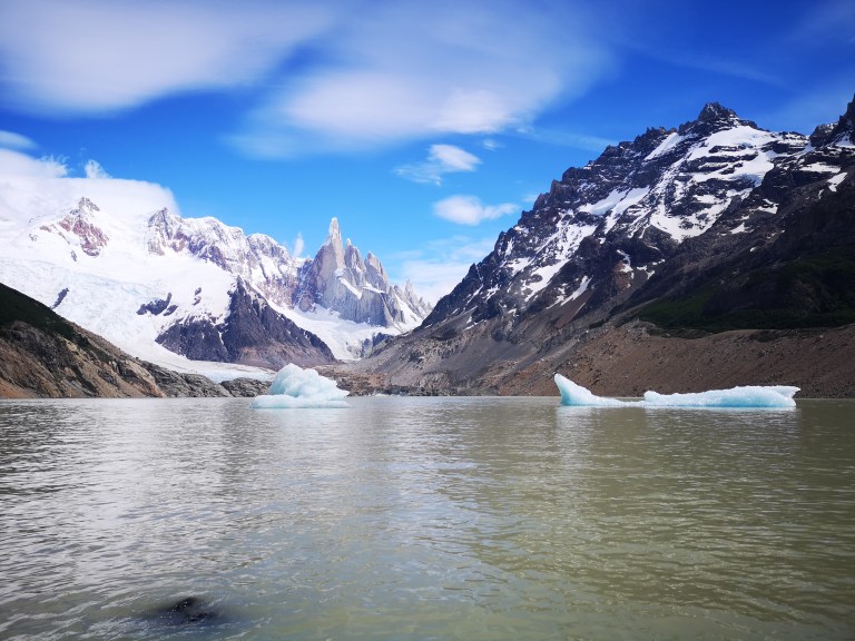
We made a two day trip, luckily the day before going to Lago de los Tres we had better weather. Starting from El Chalten we walked up to Laguna Torre (A in above map). From here we have a magnificent view on the “Torres” (three peaks)
—
Abbiamo fatto un trek di due giorni, fortunatamente il giorno prima di andare a Lago de los Tres abbiamo avuto tempo migliore. Partendo da El Chalten siamo andati fino a Laguna Torre (A in sopra la mappa). Da qui abbiamo una magnifica vista sulle “Torres” (tre cime)
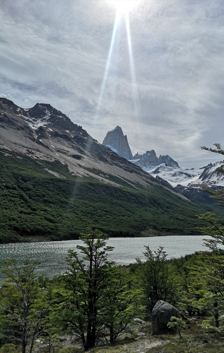
From Torres we walked to our camping Poincenot (via point G to point C) giving spectacular views of mount Fitzroy:
—
Da Torres abbiamo raggiunto il nostro campeggio Poincenot (percorso G fino al punto C) con una vista spettacolare sul monte Fitzroy:
The night in Poincenot was windy, we camped between the trees (which took away a good amount of wind) but the storm was intense. The good thing is that the tent did hold up well and did not leak during the night!
—
La notte a Poincenot era ventosa, ci siamo accampati tra gli alberi (che hanno riparato dal vento) ma la tempesta è stata intensa. La cosa buona è che la tenda ha resistito bene ed è rimasta asciutta durante la notte!

One last piece of vital information (ahum..) looking back at the skyline of El Chalten (in the first picture) you might recognise a famous outdoor brand… Patagonia took as their logo the skyline of El Chalten!
—
Un’ ultima informazione vitale (ahum ..) guardando lo skyline di El Chalten (nella prima foto) si potrebbe riconoscere un famoso marchio di abbigliamento… il brand Patagonia si è ispirato allo skyline di El Chalten per il proprio logo!

Looks stunning! We are very jealous 😉 looking forward to see more pictures of your trip!
Oli, Finn & Duncan
LikeLike